
The RainGain International Workshop on Urban Pluvial Flood Modelling took place on 6th October 2014 at the Met Office Headquarters in Exeter, UK. Ninety people attended, including practitioners and academics from a number of universities, water companies, engineering consultants, local authorities, and regional and national environmental and meteorological agencies from across Europe. Report by Susana Ochoa-Rodriguez (Imperial College London).
The workshop included short talks by international speakers, as well as interactive discussions around four main topics:
- Approaches to the modelling of urban storm water drainage systems and urban pluvial flooding
- Approaches and techniques for rapid urban pluvial (surface water) flood modelling
- Urban drainage/pluvial flood model calibration, verification and uncertainty estimation:
- Operational urban pluvial flood models for real time applications
The workshop provided an opportunity for experts to discuss recent developments in the area of urban pluvial flood modelling, as well as to review recurrent challenges. New challenges were also identified, challenges which have emerged as a consequence of the increasing availability of data, model complexity, an ever changing urban society, as well as the difficulties posed by both technological and administrative barriers, amongst other factors. The workshop served to emphasise that, although fast progress has been made in the modelling and forecasting of urban pluvial flooding over the last few years, more needs to be done to bridge the large gap that still exists between research and operational systems.
While the focus of the workshop was not on rainfall, this was a recurrent topic, as it is the driving force of urban pluvial flooding. In particular, the use of radar rainfall estimates for urban hydrological applications -including model calibration, off-line and real time applications- was mentioned in many of the presentations and was widely discussed. Below are some highlights of the discussion around this topic. More details of the workshop and links to download the presentations can be found on the RainGain project website.
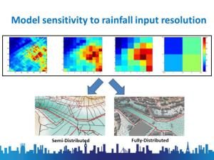
Need for understanding of scale interdependencies: The increasing availability of high resolution data (e.g. digital terrain models with centimetric resolution, fine scale radar rainfall estimates) opens a world of opportunities for urban pluvial flood modelling, including the possibility of implementing high resolution 2D and 3D models of the urban surface which allow more detailed simulation and better visualisation of urban flooding. However, it also poses numerous challenges for which solutions are yet to be found. As highlighted in the presentations by Rui Pina and Susana Ochoa (Imperial College London, UK), and Prof. Daniel Schertzer (École des ponts ParisTech, FR), one of the challenges lies in the need for better understanding of temporal and spatial scale dependencies and the need for agreement between the resolution of the datasets used for model building, of the resulting model structure, of the rainfall data used as input to the models, and of the flow/depth data that is used for calibration and verification of models. Lack of agreement between the resolutions of the different components may lead to ill‑posed models and to loss of information from the highest resolution datasets. For example, using sparse rain gauge data as input to high-resolution 2D models of the urban surface could mean that we are not fully benefiting from the high resolution of the model. Likewise, using high resolution rainfall data (e.g. 100 m / 1 min data, obtained with X-band radars or short pulse C-band radars) as input to the commonly used semi-distributed urban drainage models does not lead to tangible benefits, as compared to using currently available coarser rainfall products.
Need for assessment of added value of higher resolution data: Besides ensuring agreement in the resolution of the different datasets used in urban pluvial flood modelling, workshop participants highlighted the need to analyse the impact or added value of higher resolution data and models on final impact variables, such as flood damage / risk, on which management decisions are based. The research work presented in the workshop focused mainly on the modelling part; more research is needed in order to better understand the practical implications of the higher resolution data and models.
Gauge-based adjustment of radar rainfall estimates is essential for reducing the uncertainties of urban pluvial flood models, both for off-line and real time applications: A recurrent theme in the presentations on the topics of uncertainty quantification and real-time applications of urban pluvial flood models was the need for rainfall estimates of the highest quality, both in terms of accuracy and resolution, which can be obtained through gauge-based adjustment of radar rainfall estimates.
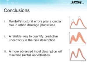
In their presentations about uncertainty quantification, Dario del Giudice (Eawag & ETH Zurich, CH) and Prof. Patrick Willems (KU Leuven, BE) demonstrated the critical role that rainfall estimates play in urban drainage modelling and hence the need for better quality rainfall estimates which take into account the spatial variability of rainfall fields, as well as for a better description of the errors associated to the rainfall estimates. This could not only improve uncertainty estimates, but could also help reduce the overall uncertainty in urban drainage models.
Next, Søren Thorndahl (Aalborg University, DK) presented his work on the automatic calibration of urban drainage models and the use of these models for real time applications, using as input radar rainfall estimates as well as radar-based nowcasted rainfall estimates. Søren demonstrated how real‑time adjustment of radar rainfall estimates could lead to significantly better modelling results.
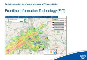
These views on the criticality of good quality rainfall inputs and the potential benefits that could be achieved through radar-raingauge merging were also shared by Stefan Kroll (Aquafin, BE), William Neale (Thames Water, UK) and Laurent Monier (Veolia, FR), who gave presentations on real-time (RT) systems for storm water management in Leuven (BE), London (UK) and the Bièvre Valley (FR), respectively. All three RT systems take as input radar rainfall estimates, the quality of which has shown to play a crucial role in the modelling outputs and associated management strategies.