Hydrological use of weather radar continues to grow across the water industry. Initiatives across many research and industry groups are aimed at maximising the value of the UK radar network and various networks of raingauges to provide the best possible spatial estimates of rainfall. This workshop provided a forum for industry leads and experts to share techniques and experiences in merging radar and raingauge data. A principle aim was to recognise any UK-wide strategic opportunities whilst recognising differing user requirements.
The science presentations were opened by Sharon Jewell (Met Office) who covered a collaborative Environment Agency and Met Office initiative for merging radar and raingauge information to support flood forecasting. Phase 1 is now complete with moves to now develop a pilot product for England and Wales and Stuart Hyslop (Environment Agency) considered the operational practicalities of using this within the flood forecasting rainfall hierarchy.
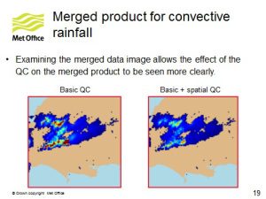
Urban drainage requirements were covered by Rod Hawnt (Hydro-Logic/Isodaq Technology). Their knowledge transfer project used joint case studies with Northumbrian, Scottish and Yorkshire Water companies and developed methods for merging dense networks of weighing gauges with radar rainfall estimates. The work of the European initiative RainGain was presented by Susana Ochoa-Rodriguez (Imperial College) which aims to improve the applicability of merged rainfall estimates for urban pluvial flood modelling and forecasting. She also touched upon the potential benefits and issues for rainfall nowcast algorithms.
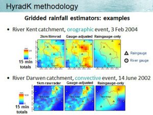
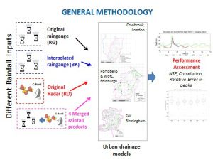
On a catchment and countrywide scale, Steven Cole (CEH Wallingford) presented on hydrological applications of radar and raingauge merging using HyradK. This method is used operationally by the Flood Forecasting Centre and Scottish Flood Forecasting Service as input to CEH’s Grid-to-Grid hydrological model. Martyn Sunter (Met Office) closed the opening session by discussing how far we could go with data sharing and exchange giving examples of the Weather Observations Website which is used for verification of forecasts.
The workshop group then considered gaps and opportunities in improving rainfall estimates through data sharing and merging techniques set against their respective user requirements. The three primary gaps in user requirements for improving rainfall estimates through merging techniques are:
- Limited studies on the benefit of high-resolution rainfall estimates (~100m, 1 min), to consider practicalities of this (data volumes) and guidance on raingauge network design strategies
- Availability of uncertainty estimates for merged rainfall products and understanding sources of uncertainties in the modelling chain
- Appropriate assessment of merged products based on end-use, e.g. hydrological model application
The three primary gaps in user requirements for rainfall data sharing across the UK are:
- The ability to effectively use large volumes of data (at high spatial/temporal resolution)
- Real-time monitoring and quality-control of data to be exchanged and the standardisation of quality information
- An archive of UK rainfall data i.e. raingauge data and their associated metadata
As a result of the various discussions the group considered the following as key opportunities to address some of these gaps:
- Met Office to put merged product and high-resolution data onto British Atmospheric Data Centre (BADC) for those in the research community
- Met Office willing to trial use of other raingauge sources with any merged product; radar/gauge merged data could be made available in return
- End-users can assess new products according to their needs/application
- Create a ‘portal’ for UK raingauge/rainfall data and define a standard approach for file formats and data exchange
- Joint procurement of networks and systems; and consider a more joined-up approach to raingauge network design
A full workshop report will be made available in due course. Any comments welcome.