Moving beyond Marshall and Palmer

Hourly rainfall accumulations graph
Hourly rainfall accumulations measured by raingauges and corresponding radar rainfall estimates from Hameldon Hill radar between 01:00 and 06:00 GMT, 4 June 2015.

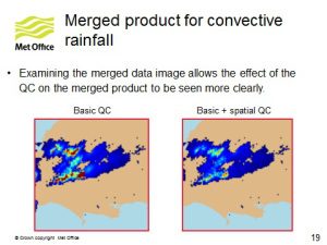
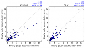
It’s nearly 70 years since Marshall and Palmer (1948) published their paper on the distribution of raindrops with size and the empirical scaling relationship equating the measured radar reflectivity, Z with the rainfall rate, R: Z= aRb. Since then, the relationship has been widely used to generate rainfall estimates from radar. With the roll-out of dual-polarisation to the UK radar network nearing completion, the Met Office is now making use of this new technology to improve radar rainfall estimates and supplement the Marshall–Palmer relationship.

Continue reading “Moving beyond Marshall and Palmer”

A retrospective of radar hydrology in the UK

Chris Collier
Christopher G. Collier became professor of Atmospheric Science at the National Centre for Atmospheric Science in 2009

After serving on the UK Inter-Agency Committee and its predecessor NERC Steering Committee since 1988, Professor Chris Collier provides a retrospective look on radar hydrology. “Radar has been used as an important tool for meteorological research, and, more recently, in operational forecasting over the last sixty years or so. However, its use in hydrology has only flowered over about half this period. In the UK the instigation of radar hydrology can arguably be traced back to the Dee Weather Radar Project (DWRP), which began in 1966, and then was referred to in 1974 as the Dee Weather Radar and Hydrology Project.

Continue reading “A retrospective of radar hydrology in the UK”

IACHUWR Committee Meeting 4th November 2014

Weather Radar Network Renewal
Weather Radar Network Renewal (Copyright Met Office)

The Inter-Agency Committee on the Hydrological Use of Weather Radar held its 60th meeting on 4 November 2014. A major focus of the meeting was to plan the 2013-2015 Session Report which is due to be published towards the end of 2015. The Committee-led workshop on merging radar and raingauge data was reviewed and the Committee agreed that its 2015-17 Community Plan should “monitor” and “encourage” research and operational implementation in this area to address the gaps and realise the opportunities identified.

Continue reading “IACHUWR Committee Meeting 4th November 2014”

Radar supporting flood forecasting in Scotland

Probability of detection of rainfall by radar compared to rainguage

There are some unique challenges with the operational use of radar in Scotland:

  • The radar coverage is inconsistent across the country, particularly in Dumfries and Galloway and the Highlands, including Inverness
  • The mountainous nature of the landscape means that the radar might not be able to “see” in all directions as the beam is blocked by hills
  • The post processing algorithms do not fully account for orographic enhancement of rainfall over high ground
  • Radar doesn’t perform very well when it is snowing due to the different reflective properties of snow compared to rain

However, radar remains a vital tool in flood forecasting as Linda Speight reports on floodforecastingservice.net

RainGain International Workshop on Urban Pluvial Flood Modelling

Attendees
Dr Crystal Moore, Head of the Flood Forecasting Centre, welcomed attendees and highlighted the risk that urban pluvial (surface water) flooding poses to England

The RainGain International Workshop on Urban Pluvial Flood Modelling took place on 6th October 2014 at the Met Office Headquarters in Exeter, UK. Ninety people attended, including practitioners and academics from a number of universities, water companies, engineering consultants, local authorities, and regional and national environmental and meteorological agencies from across Europe. Report by Susana Ochoa-Rodriguez (Imperial College London).

Continue reading “RainGain International Workshop on Urban Pluvial Flood Modelling”

IAHS Red Book: Weather Radar and Hydrology

Weather Radar and Hydrology BookWeather Radar and Hydrology 2011 provided a forum for the exchange of experiences and ideas on the use of weather radar in hydrology with a particular emphasis on user applications for flood forecasting and water management. The full set of papers from the symposium, held at the University of Exeter in April 2011, are available through the International Association of Hydrological Sciences

Continue reading “IAHS Red Book: Weather Radar and Hydrology”

Merging radar and raingauge data: opportunities for a future UK-wide strategy

Met Office Powerpoint Slide
Approaches to radar and gauge merging by the joint Met Office and Environment Agency initiative

Hydrological use of weather radar continues to grow across the water industry. Initiatives across many research and industry groups are aimed at maximising the value of the UK radar network and various networks of raingauges to provide the best possible spatial estimates of rainfall. This workshop provided a forum for industry leads and experts to share techniques and experiences in merging radar and raingauge data. A principle aim was to recognise any UK-wide strategic opportunities whilst recognising differing user requirements.

Continue reading “Merging radar and raingauge data: opportunities for a future UK-wide strategy”

Improving rainfall estimation for water industry use by merging radar and raingauge data: A UK-wide strategy

Rainfall Radar Image
A narrow band of heavy rain showers squall line moving across the south of England

Providing the best possible spatial representation of rainfall is vital to support hydrological applications, whether for urban drainage management or flood forecasting. This principle applies at various spatial and temporal scales for rainfall estimates in both gridded and catchment-average form.

Continue reading “Improving rainfall estimation for water industry use by merging radar and raingauge data: A UK-wide strategy”

Radar Hydrology in the UK

Met Office RadarThe Inter-Agency Committee on the Hydrological Use of Weather Radar is the only national body in the United Kingdom bringing together operational agencies and research bodies with the common purpose of advancing the use of weather radar in hydrology, especially in support of flood management. It operates under the auspices of stakeholder organisations and with support from the Natural Environment Research Council (NERC). We promote and encourage research in this area.

Continue reading “Radar Hydrology in the UK”