It’s nearly 70 years since Marshall and Palmer (1948) published their paper on the distribution of raindrops with size and the empirical scaling relationship equating the measured radar reflectivity, Z with the rainfall rate, R: Z= aRb. Since then, the relationship has been widely used to generate rainfall estimates from radar. With the roll-out of dual-polarisation to the UK radar network nearing completion, the Met Office is now making use of this new technology to improve radar rainfall estimates and supplement the Marshall–Palmer relationship.
The reflectivity, Z, has deficiencies in estimating rainfall, in that it is affected by radar miscalibration, attenuation, partial beam blocking, and is sensitive to drop size distribution (DSD) variations, (Z is proportional to the sixth power of the drop diameter). These deficiencies in using Z often cause underestimation in radar rainfall rate products when compared to raingauge measurements.
A more direct way of estimating the rainfall rate comes from using dual polarisation radar to measure the differential phase and derive an estimate of the specific differential phase or KDP. Using KDP is an attractive approach as it is more linearly related to the rainfall rate. However, for the C-band radars in the UK network, KDP is only usable at the higher rainfall rates and so a merged Marshall-Palmer and KDP approach has been developed by Steven Best at the Met Office.
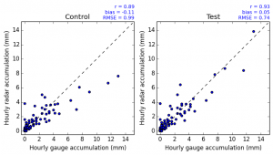
The merged approach involves using the Marshall-Palmer relationship at lower rainfall intensities and using KDP at higher intensities. Testing during Summer 2015 and comparison with the existing Marshall-Palmer only approach showed that the merged method produced rainfall estimates which were much better correlated with the corresponding raingauge measurements and reduced the error variance and bias. Example comparisons between radar estimates and raingauge measurements of rainfall during an event in July 2015 are shown in Figure 1. Whilst last summer this algorithm was only on test, the algorithm was released to Radarnet IV, the Met Office radar central processing system, in November 2015 and is now being used to generate our real-time rainfall estimates from the upgraded dual-polarisation radars.
Capturing the higher intensity rainfall more accurately will give downstream users of radar rainfall data (e.g. for precipitation nowcasting or flood and urban drainage modelling) increased confidence in using these data to make operational decisions, and in particular during those extreme events when it really matters.
Blog written by Katie Norman, Radar Products R&D Manager, Met Office.
Acknowledgements. This work was partly funded by the Environment Agency, Flood Forecasting Centre and the Public Weather Service under the project: Radar Accuracy: Optimising the Benefits of Radar Network Renewal Through Improvement to Dual Polarisation (SC130007)
Further reading
Marshall, J. S., and W. McK. Palmer (1948) The distribution of raindrops with size. J. Meteor., 5, 165–166.